An efficient solution for quickly adding geo location information to your photos by extracting it from track logs or GPS files, or by adding the coordinates manually #Image geocoding #Add EXIF #Add image coordinates #Geocoding #EXIF #XMP
If you are taking photos using a GPS enabled device, the image file metadata will automatically include geo location information. However, if you are not using a gadget that comes with GPS, but you still want to embed this type of information within your photos, the HoudahGeo Mac app gives you a helping hand.
HoudahGeo is able to geotag your photos by matching photos to GPS track logs or by allowing you to pinpoint locations on a map. Moreover, you may also provide the longitude and latitude coordinates manually.
The HoudahGeo main window is organized in three tabs, according to the app’s workflow: first you get to Load the images, then you must Process them by assigning geo location details, and last, you can export them to various output formats.
Each HoudahGeo tab contains toolbars and panels that provide quick access to different tools related to the current processing stage.
In the HoudahGeo Load area you can set up your own media library by importing various folders, but the app also integrates with your iPhoto, Aperture and Lightroom albums. You can also import track logs and GPS files that will be useful for the next step.
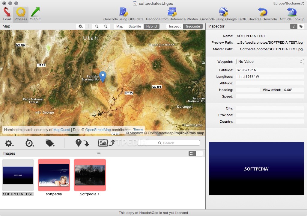
In the HoudahGeo Process tab you get to explore a map in normal, satellite and hybrid view modes, find the location where the picture has been taken an press the “Geocode” button to add the latitude and longitude coordinates. The same area allows you to input the altitude, direction, offset, speed, city, province and country.
In the HoudahGeo Output tab you get to decide how do you want to save the metadata: you can embed it to the file using the EXIF and XMP protocols, you can notify iPhoto or Aperture about the changes or export to Google Earth format.
Other options include generating KML, CSV or GPX projects. HoudahGeo allows you to publish the photos to Evernote, EveryTrail, Flickr or Locr.
HoudahGeo will prove to be a very useful tool if you need to embed geo location metadata to your photos by extracting information from various sources. At the same time, the large number of exporting options allows you to share the results on various mediums.
What's new in HoudahGeo 6.4.3:
- Adds support for Adobe Lightroom Classic 13.
HoudahGeo 6.4.3
add to watchlist add to download basket send us an update REPORT- runs on:
- macOS 10.14 or later (Intel only)
- file size:
- 28.7 MB
- filename:
- HoudahGeo_latest.zip
- main category:
- DTP/Prepress
- developer:
- visit homepage
Windows Sandbox Launcher

calibre

IrfanView

7-Zip

ShareX

Zoom Client

Microsoft Teams

4k Video Downloader

Bitdefender Antivirus Free

Context Menu Manager

- 4k Video Downloader
- Bitdefender Antivirus Free
- Context Menu Manager
- Windows Sandbox Launcher
- calibre
- IrfanView
- 7-Zip
- ShareX
- Zoom Client
- Microsoft Teams